
For the people of Guam, the current time is the calm before The Storm. A Super Typhoon Sinlaku churns across the Philippine Sea, targeting Northern Marianas and Guam, the island that once again finds itself in the “Typhoon Alley” of the Pacific. The archipelago is bracing for a direct impact by one of nature’s most relentless forces.
Super Typhoon Sinlaku has undergone rapid intensification over the last 24 hours, defying early forecasts, and has become the most powerful storm on the planet so far in 2026.

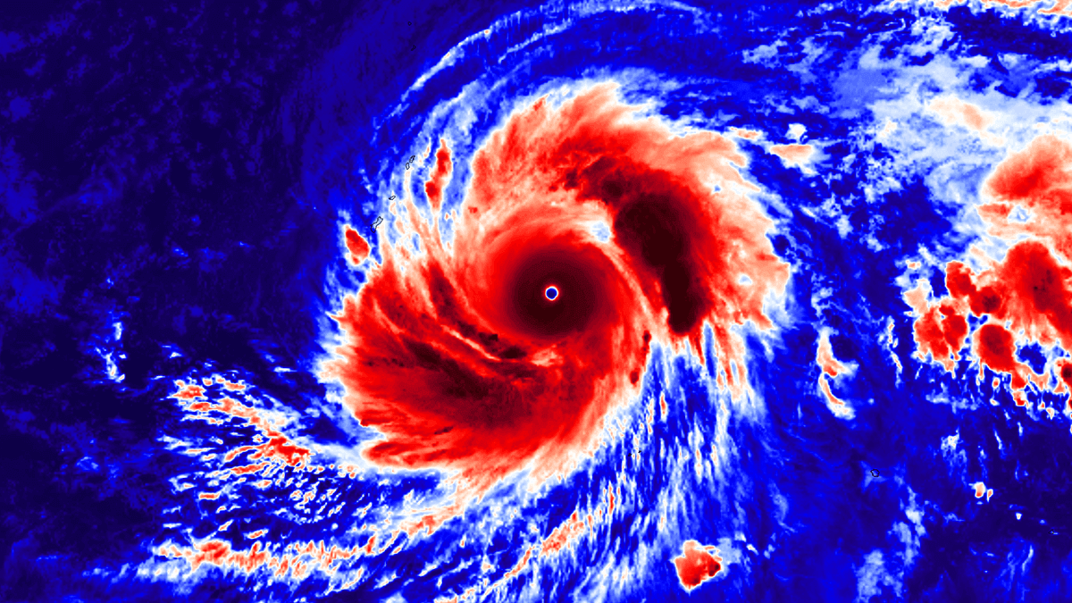
The early local Monday morning visible satellite image revealed that Sinlaku is an incredibly powerful typhoon, and has grown to a very large system after a massive, rapid intensification over the weekend.
The Category 5 Super Typhoon is now sustaining winds up to 155 knots (180 mph) with a central pressure of 896 mbar. This is an extremely intense Pacific storm.
The latest Advanced Dvorak automatic satellite analysis suggests the typhoon is likely even more intense, with winds up to 164 knots and a central pressure of around 888 mbar. Based on the lightning activity in the eyewall, Sinlaku is still rapidly strengthening.
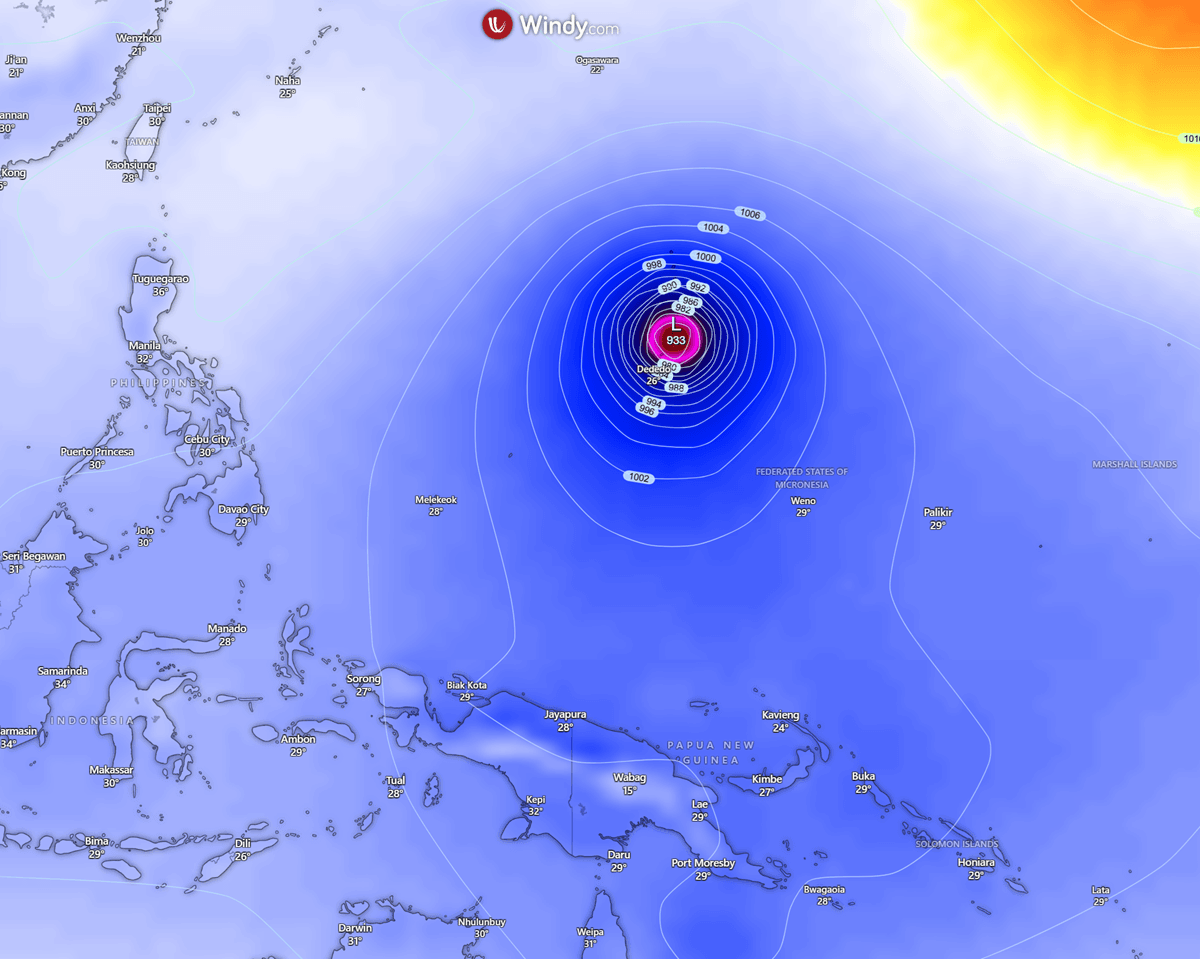
While the island of Guam remains under a watch of how intense the impact will be, the latest tracking data has shifted the cone of potential most severe impact to the Northern Marianas. The storm’s central pressure has plummeted to 896 mbar, thanks to the raw energy Sinlaku has ingested from the unusually warm April sea waters.
Meteorologists are warning of an extremely dangerous direct hit, with the eyewall projected to move across the islands of Saipan and Tinian with the force of a high-end Category 4 or even Category 5 storm. Either way, the impact could be disastrous.
As mentioned, Guam lies in the so-called “Typhoon Alley” where intense tropical systems are tracked as they move across the Western Pacific. To understand the potential impact of Sinlaku, one must look back at the benchmarks of destruction that have shaped Guam’s modern infrastructure and emergency protocols.
Several intense typhoons in recent years have hit the Marianas, including Karen, Paka, and Pongsona. Typhoon Karen changed everything; prior to 1962, most homes were wooden. Today, Guam is a ‘concrete island’ which has become so specifically because of these statistics.
Note that Guam’s Tropical Cyclone Conditions of Readiness (TCCR) system is one of the most sophisticated in the world.
- Super Typhoon Karen (1962) had maximum sustained winds of 185 mph and is known as the ‘benchmark’ storm. Karen has destroyed 95 % of homes and led to Guam’s modern concrete building codes.
- Typhoon Paka (1997) produced 236 mph winds, a record wind gust at Andersen AFB (later disputed but remained legendary), and left the island without power for weeks. Meteorologists later officially estimated sustained winds at 115–125 knots (132–144 mph) due to equipment failure during the storm’s peak.
- The third most intense typhoon for Guam was Pongsona (2002), which brought 173 mph winds and caused a massive fire at the Port Authority fuel tanks and $700M+ in damages. This was the last major impact before a 20-year “lull.”
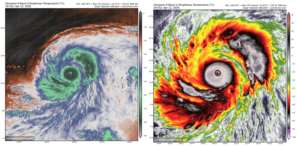
Super typhoon Sinlaku went through explosive phases this weekend, following unusually warm oceanic waters in the Western Pacific, a trend observed in recent years. Note that strongly anomalous waters support more rapid strengthening of tropical cyclones, leading to their higher peak intensity.
The animation below indicates how Sinlaku has experienced rapid strengthening over the past 24 hours.
The key message – current weather advisory:
- Storm classification: Super Typhoon
- Maximum sustained winds: 155 knots / 180 mph / 290 km/h
- Central pressure: 896 hPa
- Primary threat: Saipan, with most likely a direct hit with landfall early Tuesday; Guam, with high-end Tropical storm winds and flooding
- Rainfall: 15–20 inches expected near the core
Let’s examine the region’s ongoing conditions, the forecast tracks, and the impact of both storms.
Above normal sea water temperatures across the tropical western Pacific
Sea temperatures across the western tropical Pacific remain extremely high this month, ranging from 28 to 31 °C. They are slightly cooler further north across the Marianas but remain in the 28-29 °C range.
These high water temperatures lead to higher dew points and elevated near-surface energy, so convective storms ingest this volatile air mass and support explosive thunderstorm activity.
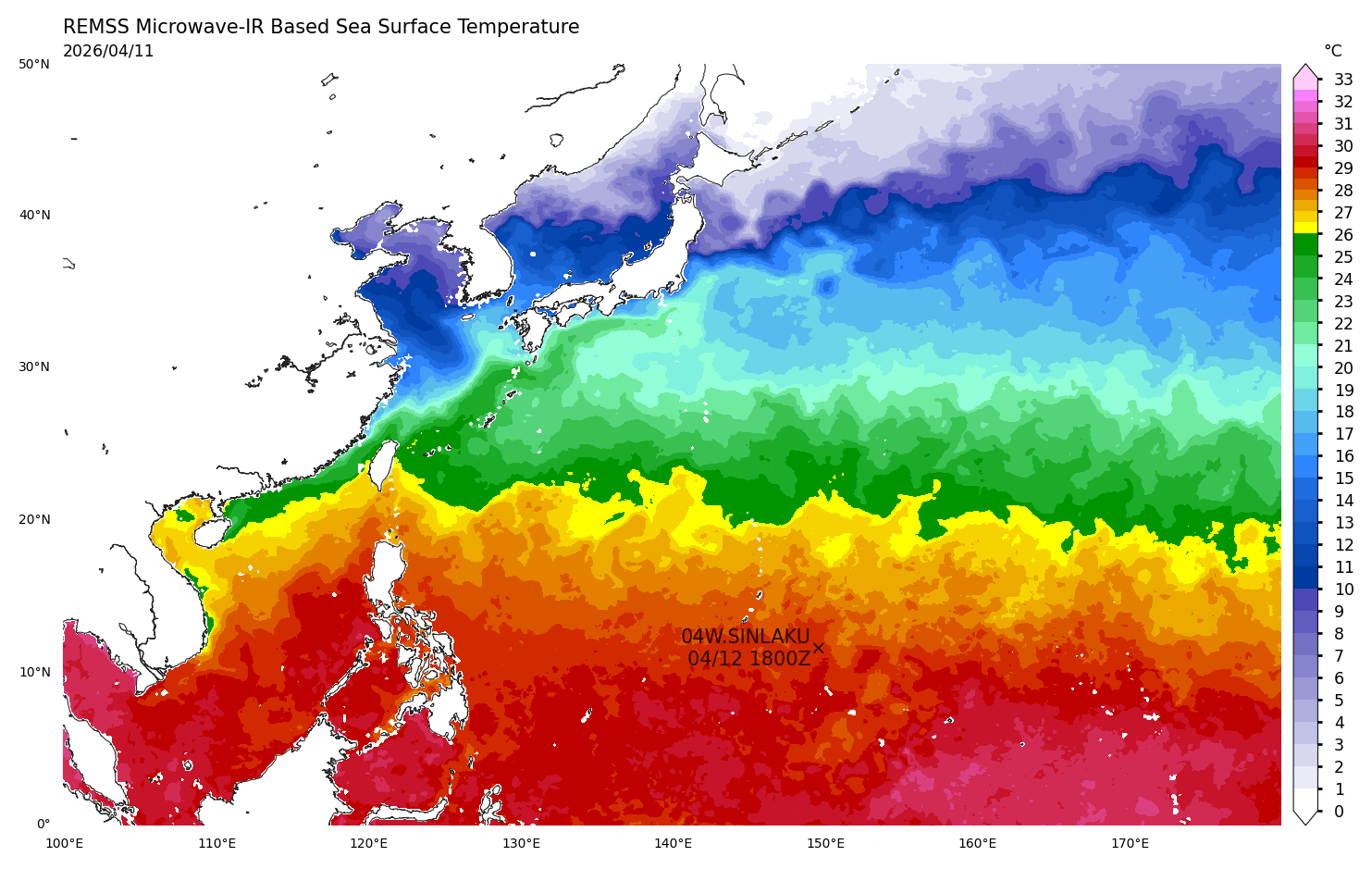
Sea surface temperatures are about 2-3 °C above the usual for mid-April in the region, and they are even warmer across the central tropical Pacific.
Notice that sea waters remain extremely anomalous towards the coast of China, Taiwan, and Japan, with even more than 4 °C above the long-term average.
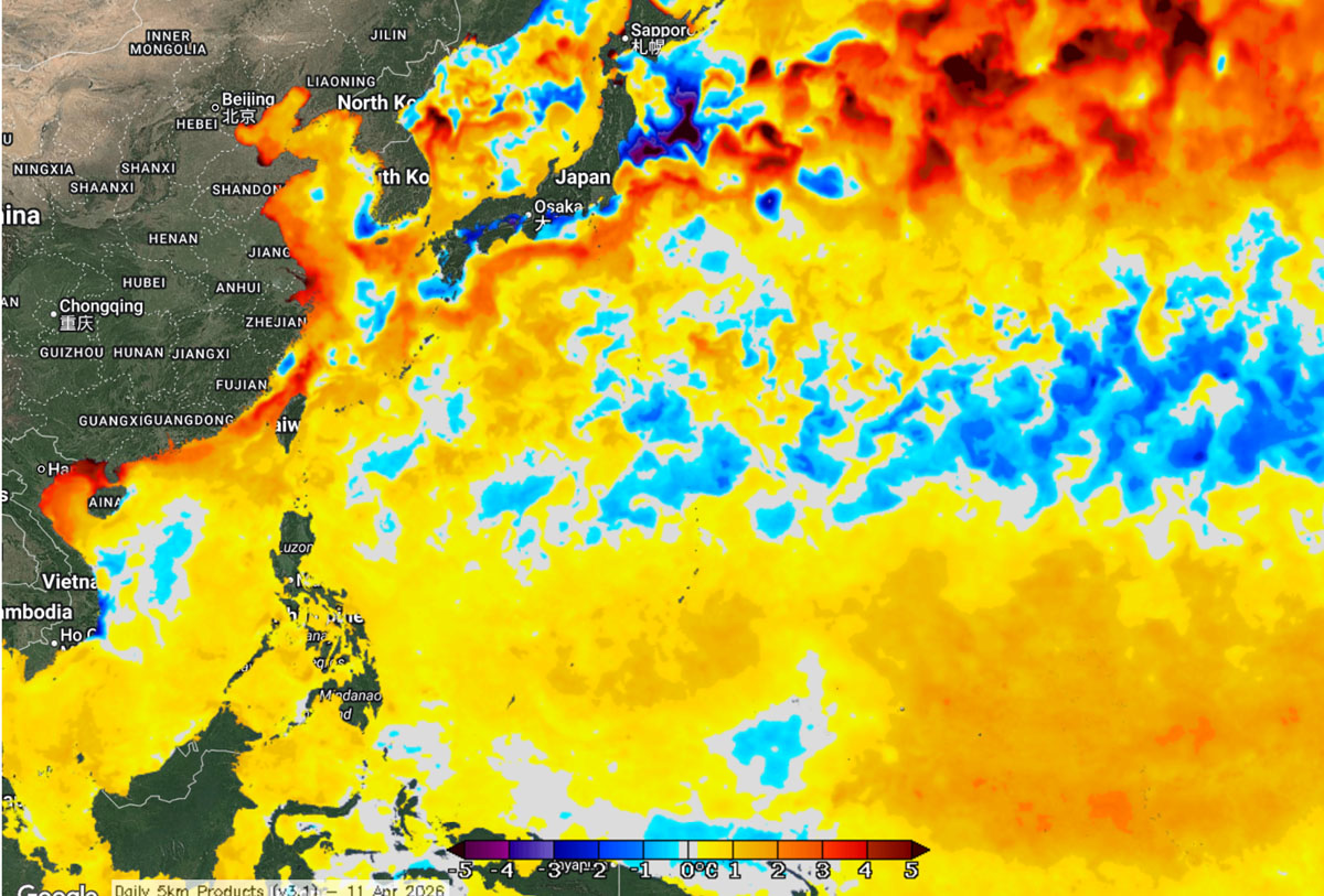
Any tropical system that emerges into such hot waters gains strength and power.
This is precisely what has happened with Super Typhoon Sinlaku over the weekend. Extremely high water temperatures led to its rapid intensification into a Category 5 monster storm.
Super typhoon Sinlaku becomes the world’s strongest storm of 2026
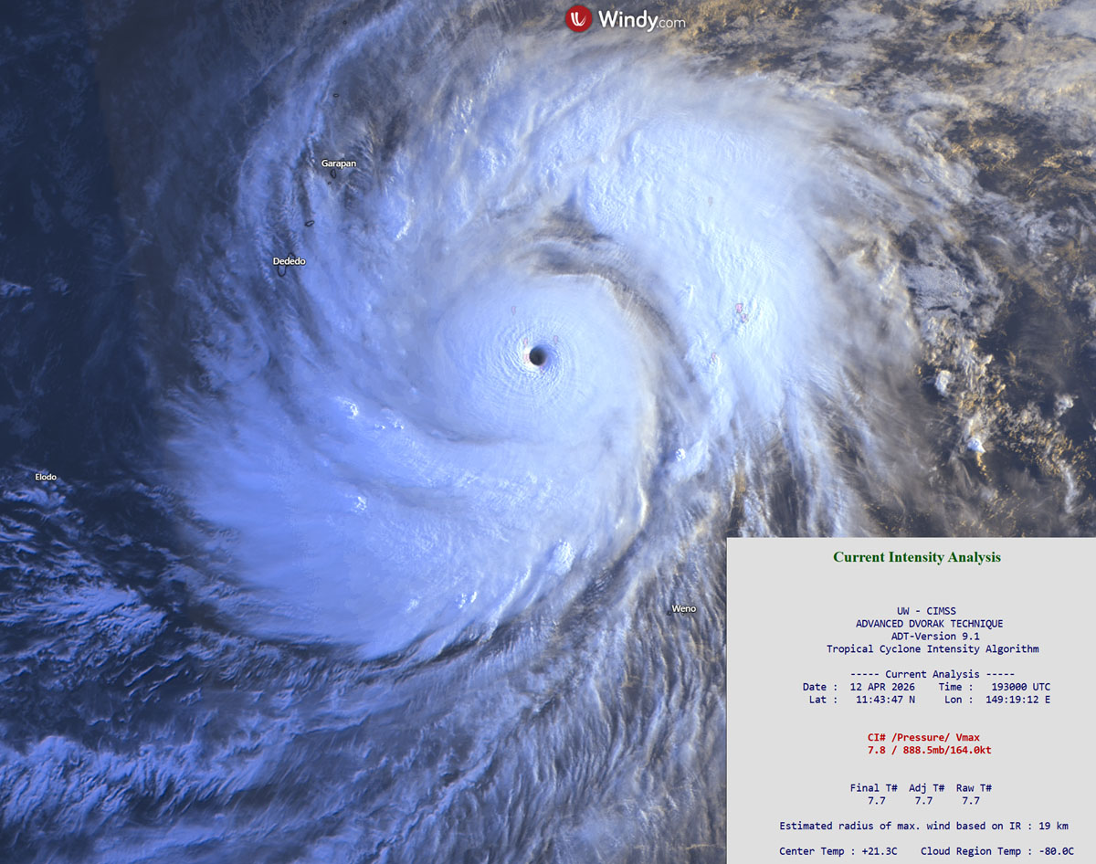
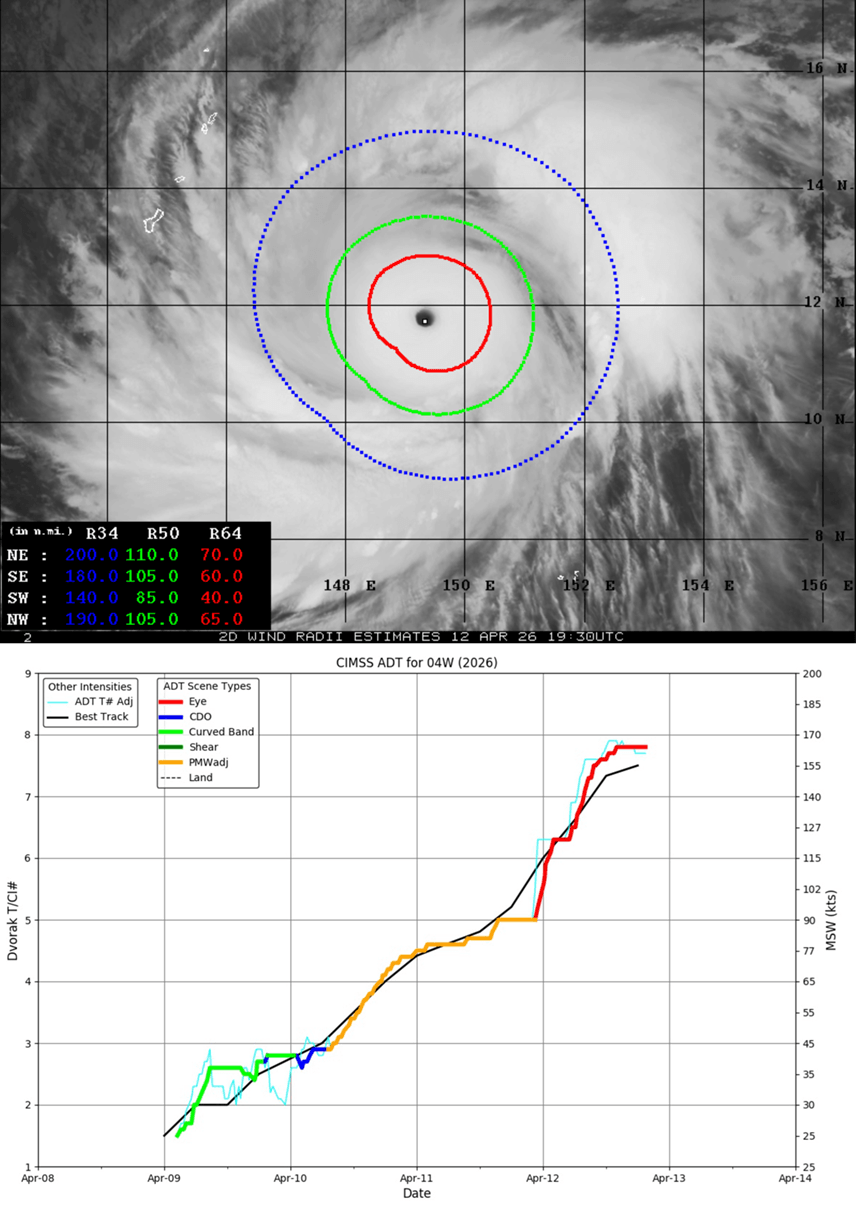
The automatic satellite analysis of the Super Typhoon Sinlaku indicates that the estimated peak winds are near 165 knots, which aligns with the 7.7 Dvorak intensity. This is a Super typhoon with the status of a Category 5 storm.
The most intense winds extend 60-70 miles from the core in all quadrants, indicating a symmetrical, expanding wind field. Tropical-storm-force winds extend up to 110 miles from the large eye.
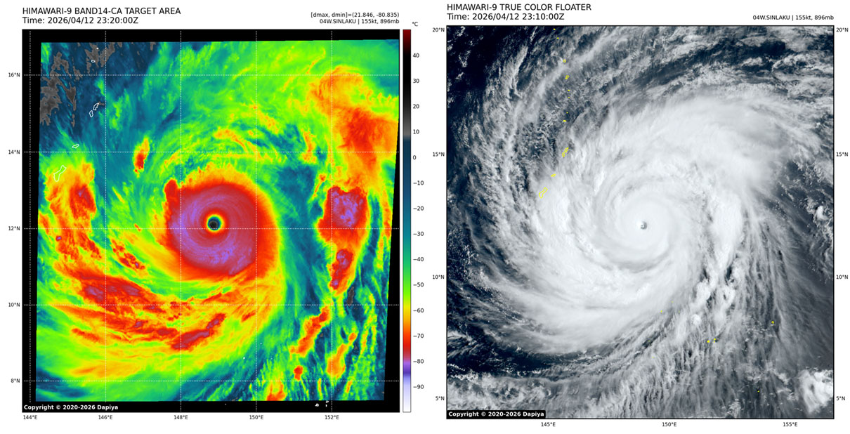
The infrared satellite shows how impressively large Sinlaku already is. In addition to the typhoon’s whole structure, Marianas and Guam are really tiny.
Through Monday, Sinlaku will continue tracking west-northwest while strengthening and maintaining its Category 5 strength.
The most likely scenario involves Typhoon Sinlaku crossing the northern Marianas, with islands Tinian and Saipan in the storm’s direct path. With the high-end Category 4 or even Category 5 strength. Violent, destructive winds, catastrophic storm surges, giant waves, and flooding rain will blast the islands. The damage will be extreme.
According to the weather models, the worst will miss Guam, though high waves and currents will affect coastal areas, along with tropical-storm winds. Guam will be spared the worst.
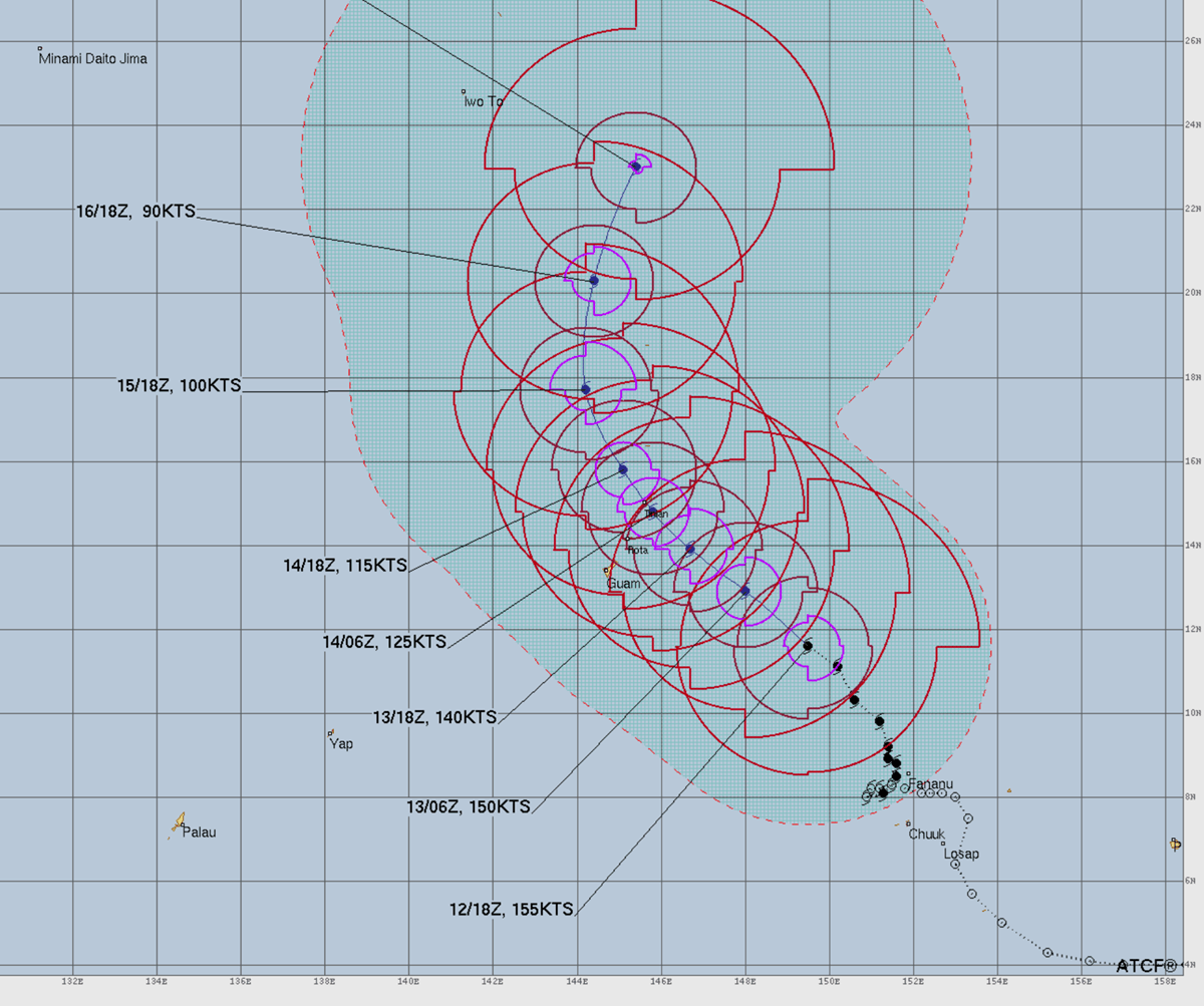
Once Ragasa crosses the Northern Marianas, it will gradually weaken while turning towards the north-northwest, passing to the east of Iwo To island.
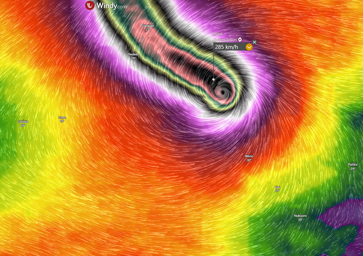
Sinlaku is set to deliver a destructive impact to the Northern Marianas
Here is a close-up model view of Super Typhoon Sinlaku on early Monday as it tracks towards the Northern Marianas. A potent impact is expected.
The wind field is very large, extending hurricane-force winds up to 100-120 miles around the eye.
The central pressure could once the storm nears Tinian and Saipan could be around 920-930 mbar, although the weather models are hardly accurate in forecasting this, and pressure could remain much lower if no significant changes in intensity occur.
Normally, eyewall replacement cycles (ERCs) occur with these cyclone sizes and intensities. When they occur, fluctuations in intensity follow, so the future intensity strongly depends on those.
Low pressure and a tight pressure gradient support destructive winds, which will gust well above 200 km/h. Global weather models are likely underestimating peak gusts, as the current Dvorak satellite analysis indicates wind gusts exceed 300 km/h.
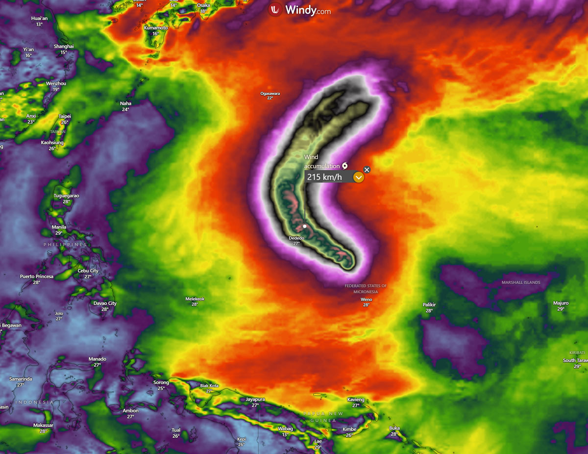
The following chart indicates the likely swath of the most severe winds, passing across Northern Marianas on Tuesday and then gradually turning north and northeast through midweek.
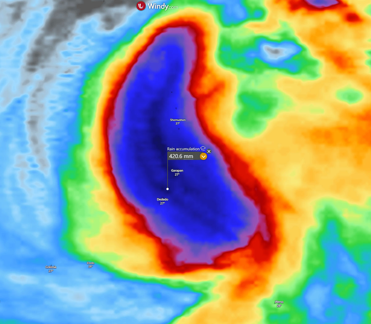
Usually, the most robust thunderstorms with intense rainfall and downpours surround the eye, following the most extreme activity in the eyewall.
This is also where the most significant rainfall is expected. Some weather models predict that 350-400+ mm will likely fall along its path.
Once the storm crosses the Tinian and Saipan islands, it will begin to weaken as it tracks north and then northeast through mid- and late this week.
Windy, CyclonicWX, and Tropical Tidbits provided images used in this article.
See also: