After weeks of stable, unseasonably warm spring-like weather in many parts of Europe, Mother Nature is preparing to deliver a sharp reminder that winter isn’t over yet. A significant shift in the hemispheric pattern is underway, bringing a winter storm with cold, snow, and potentially damaging freezes to many parts of the European continent.
After the final collapse of the Polar Vortex, a massive jet-stream disruption blocks the Atlantic, sending a deep Arctic upper-level trough towards Europe. It will bring much colder temperatures across the heart of Europe.
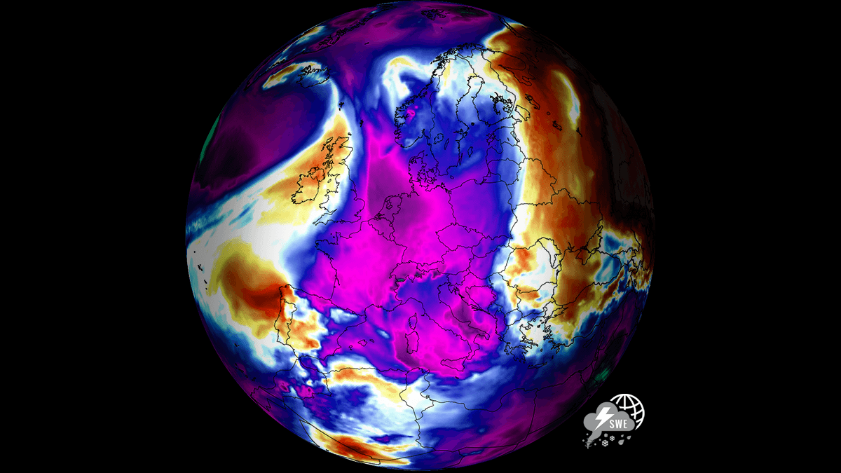
This upcoming weather setup will act as a conveyor belt for Arctic maritime air, effectively ending the ‘Spring tease’ that was underway since the beginning of March. It will replace it with a widespread wintry cold regime, a sharp 15 to 20 °C drop in temperature within two days, accompanied by the return of frost and locally significant late-season snowfall.
A few Key Highlights for the Great March Reversal:
The timeline: The weather transition begins on Monday, with the blocking High establishing over the North Atlantic, sending a deep core of Arctic air into Western and Central Europe by mid-week.
The sharp temperature plunge: We expect a dramatic flip from springtime weather back into wintry mode. Many regions currently enjoying 15-20 °C will see temperatures nearly 20 °C lower in two days.
Snow potential: Widespread snow is forecast for Central Europe and the Balkans (more than 50 cm in some areas), with accumulating snow likely also for parts of the UK, Benelux, Germany, France, Czechia, Slovakia, and Poland.
Agricultural threat: Dangerous frost potential. Severe nighttime frosts are likely to follow clear nights after snowfall and an Arctic front, with -3 °C to -7 °C in lowlands, threatening vineyards and fruit orchards across Western and Central Europe that have already begun to bud.
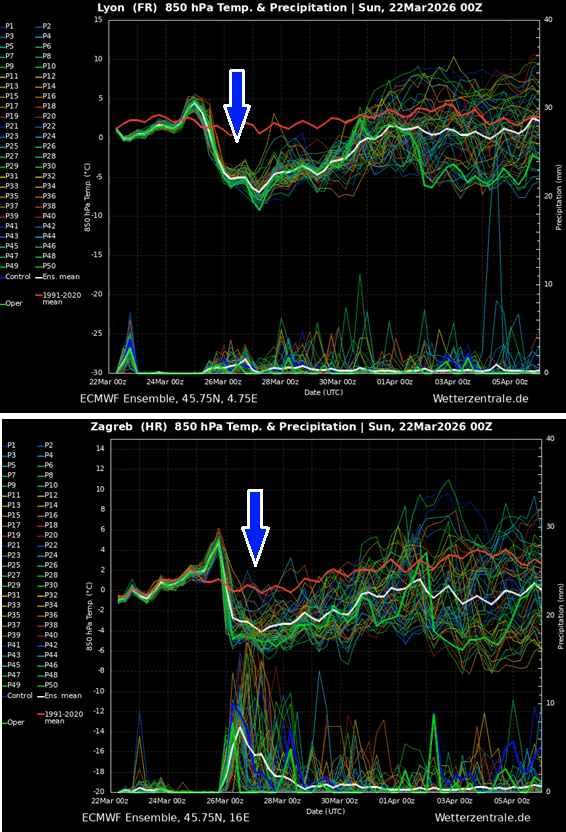
The sharp temperature change behind the Polar front and the longevity of the cold pool are shown in the meteogram charts above for Lyon, France, and Zagreb, Croatia. The latter also hints at a potentially decent amount of fresh snow over the broader northern Balkan region.
This weather scenario, shaping up in the final days of March 2026, represents a classic late-season Arctic plunge into Europe, driven by the interaction between a displaced Polar Vortex lobe, a powerful jet stream, and the Blocking High over the Atlantic.
Following a major Stratospheric Warming earlier this month, the final disruption and the collapse of the Polar Vortex occurred. It first sent the Arctic outbreak across North America, while its southern lobe has now shifted towards the European side of the Northern Hemisphere.
This will bring a major cold wave due to an Arctic air intrusion, with a deep trough emerging over the European continent this week. A full-scale displacement of Arctic air towards Europe brings a prolonged period of more dynamic weather, with wintry conditions, snow, and deep freezes.
Before we dig into the details of this impactful Winter Storm, it is essential to understand the background mechanisms governing the Polar Vortex.
What is the Polar Vortex?
The Earth’s atmosphere has six layers. Most of the dynamics of our daily weather occur in the lowest two layers of the atmosphere, the troposphere and the stratosphere.
The troposphere is the layer closest to the Earth’s surface. It is about 12 km deep and extends from the ground up high into the sky. Depending on where you live, its depth varies from around 8 km to almost 20 km. The troposphere is deepest over the equatorial region and becomes much thinner over the North and South poles.
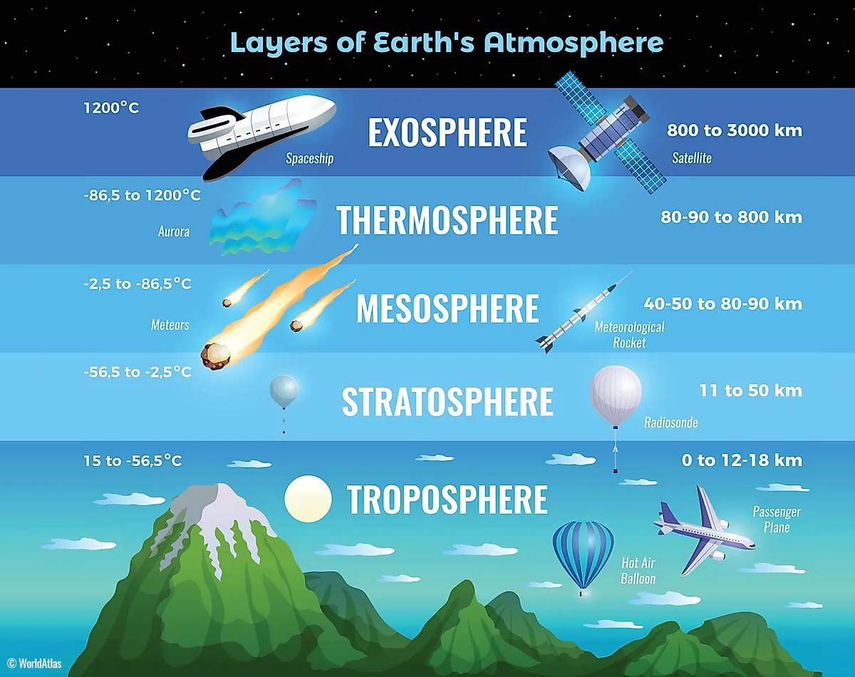
Above this layer is a much deeper one known as the Stratosphere, an 11-50 km thick layer of arid air. Another essential feature in the stratosphere, which makes our weather even more variable, often triggers significant, large-scale, long-lasting winter weather events.
This is the Polar Vortex—an enormous, tri-dimensional ring of powerful winds moving through the sky above us. The Polar Vortex is spinning around the North Pole, grazing through the air at about 20-50 km above the Earth’s surface with violent wind speeds.
How and when does the Polar Vortex form?
Due to the Earth’s inclination, the polar regions receive much less energy from the Sun during the fall months. This makes the cooling over the northern areas more robust. As a result, polar nights can last several consecutive months, followed by days without sunlight.
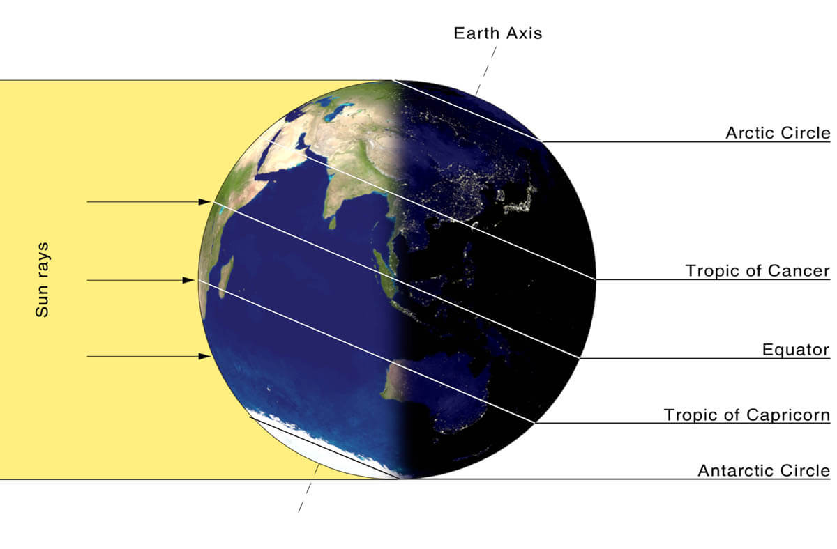
While temperatures in the polar regions are dropping into a deep freeze, the atmospheric layers farther to the south are still relatively warm because they receive more of the Sun’s energy at the same time. Therefore, the south’s equatorial layers remain much warmer than the areas farther north, leading to a high-temperature contrast.
Cooling the polar regions also lowers the ambient surface pressure, and a similar weather process occurs in the stratosphere. The temperature difference between the North Pole and the equatorial areas increases across both layers.
This creates a large, low-pressure cyclonic circulation across the polar stratosphere, which gives it its famous name—the Polar Vortex.
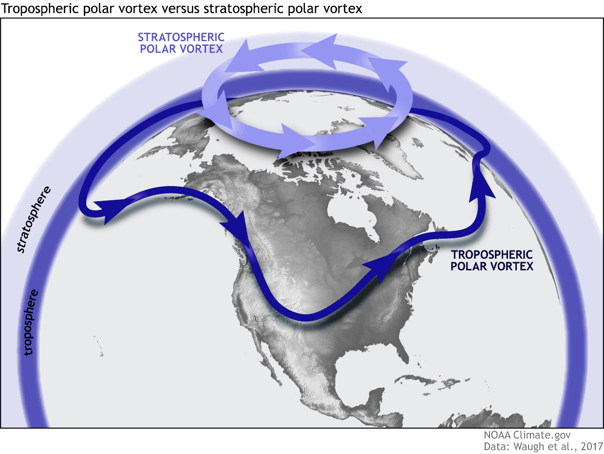
As shown in the image above, we monitor two atmospheric layers during wintertime: the troposphere and the stratosphere. The first is the lowest layer, and the second is at a higher altitude. The Polar Vortex rises through both layers, but with different strengths, shapes, and impacts.
For this reason, we separate the entire Polar Vortex into an upper (stratospheric) and a lower (tropospheric) part. When the Polar Vortex is strong, it traps colder air in the polar regions, preventing its escape and creating milder conditions for most of the United States, Europe, and other mid-latitudes.
But when the Polar Vortex gets disrupted or even entirely collapses, it can’t fully contain the cold air, which can now easily escape from the polar regions into the mid-latitude regions. Below is an example of how a disrupted Polar Vortex brings cold polar air into the United States and Europe.
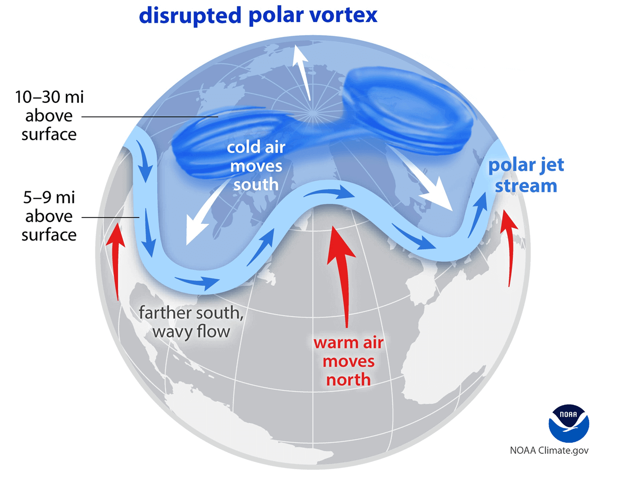
We have experienced this in Asia, Canada, the U.S., and sometimes Europe in recent years. The vortex aloft has been significantly disrupted this season, and when its lobe shifts away from the North Pole, the extreme cold grips the North American continent.
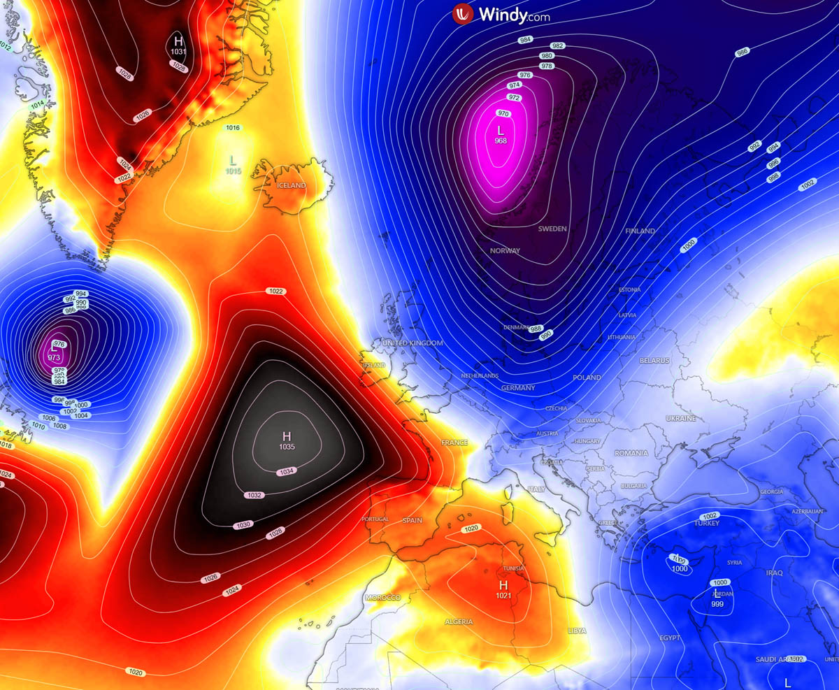
A large block forms over the Atlantic, sending a polar trough into Western and Central Europe by mid-week
The upcoming weather pattern evolving indicates the North Atlantic and the Greenland Block, a textbook example of high-latitude blocking. On its eastern flank, the polar jet stream allows a deep Arctic trough to plunge towards the European continent.
The powerful blocking High prevents the milder Atlantic air from reaching the continent, allowing an undisturbed corridor for cold, polar air to flow from the north into the heart of the continent.
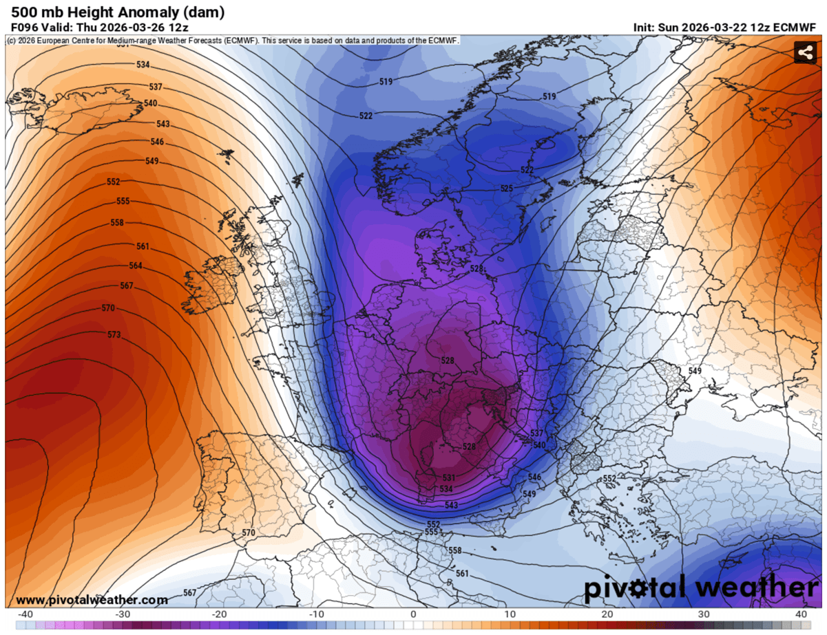
This shift is driven by a classic meridional flow from the Arctic, allowing the southern lobe of the Polar Vortex to break away and dive toward Central Europe and the Mediterranean.
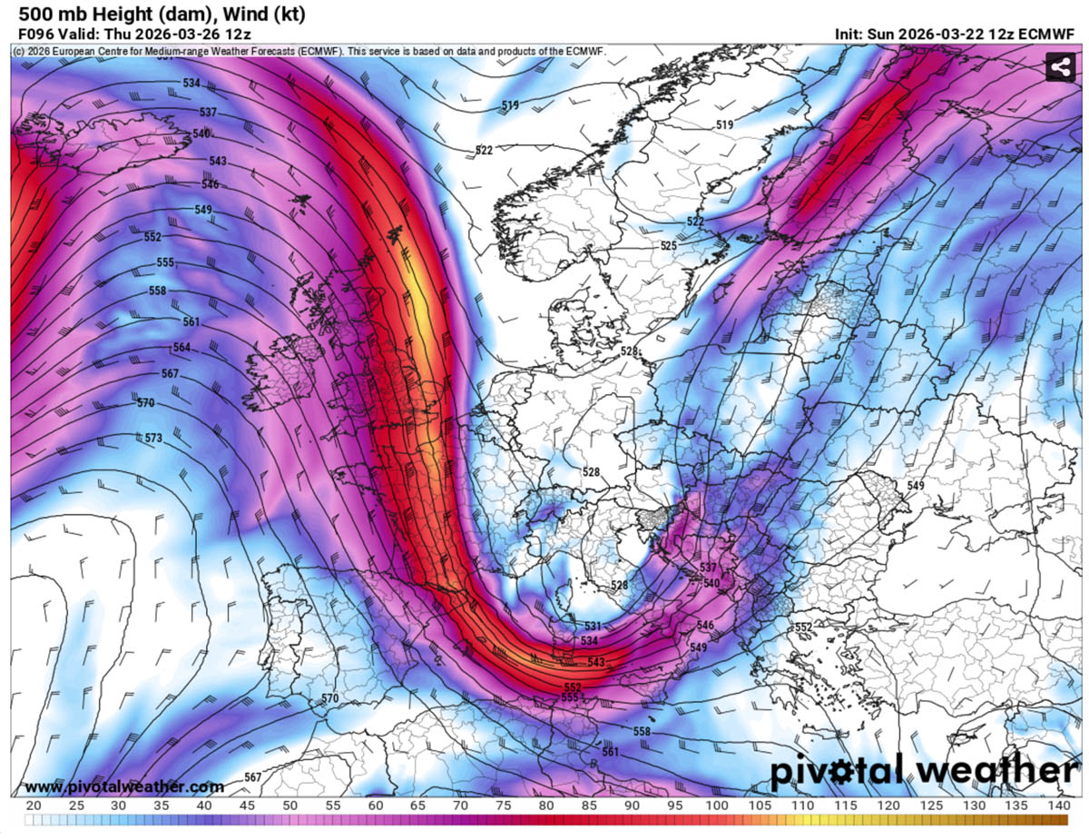
An amplified jet stream establishes a prolonged period of a much colder, wintry, and dynamic weather pattern for Europe through the remainder of March. Mid-range trends also suggest the jet stream could potentially extend the cold pattern into early April.
Following the strong blocking High, the surface response brings a large high-pressure system over the North Atlantic with deep frontal systems and winter storms blasting into North and Central Europe.
A large and powerful deep low will take place over the northern half of Europe through mid and late week.
The overall result of this cold air mass colliding with returning Mediterranean moisture over Central Europe is that a series of secondary surface lows will develop. Triggering widespread precipitation that will transition from rain to snow as the freezing levels plummet after Tuesday through Wednesday and Thursday.
Polar front clashes with the warmer south, with an active winter storm emerging into central Europe
The frontal system associated with the deep low over Northern Europe advanced southeastward across Western Europe on Tuesday, bringing a significant temperature drop back into the colder season. By Wednesday, the cold wave reaches the Alpine region, developing a secondary surface low over the Northern Mediterranean.
An explosive Genoa Low develops, moves across Italy to the Adriatic Sea and the Balkans, and intensifies through Thursday. This develops a very powerful frontal system, with rapidly deteriorating weather conditions. Developing heavy rainfall, soon clashing with the Arctic air mass, and changing precipitation to snow. Blizzard conditions will develop over the Balkans as well.
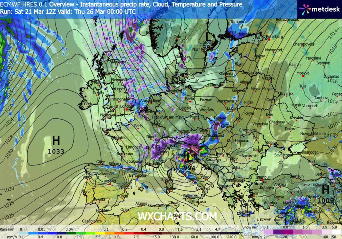
As the low matures over the north-central Mediterranean and the Balkans, the frontal system and winter storm stalls over the region for several days, with wintry weather forecast. The system gradually shifts east over the weekend.
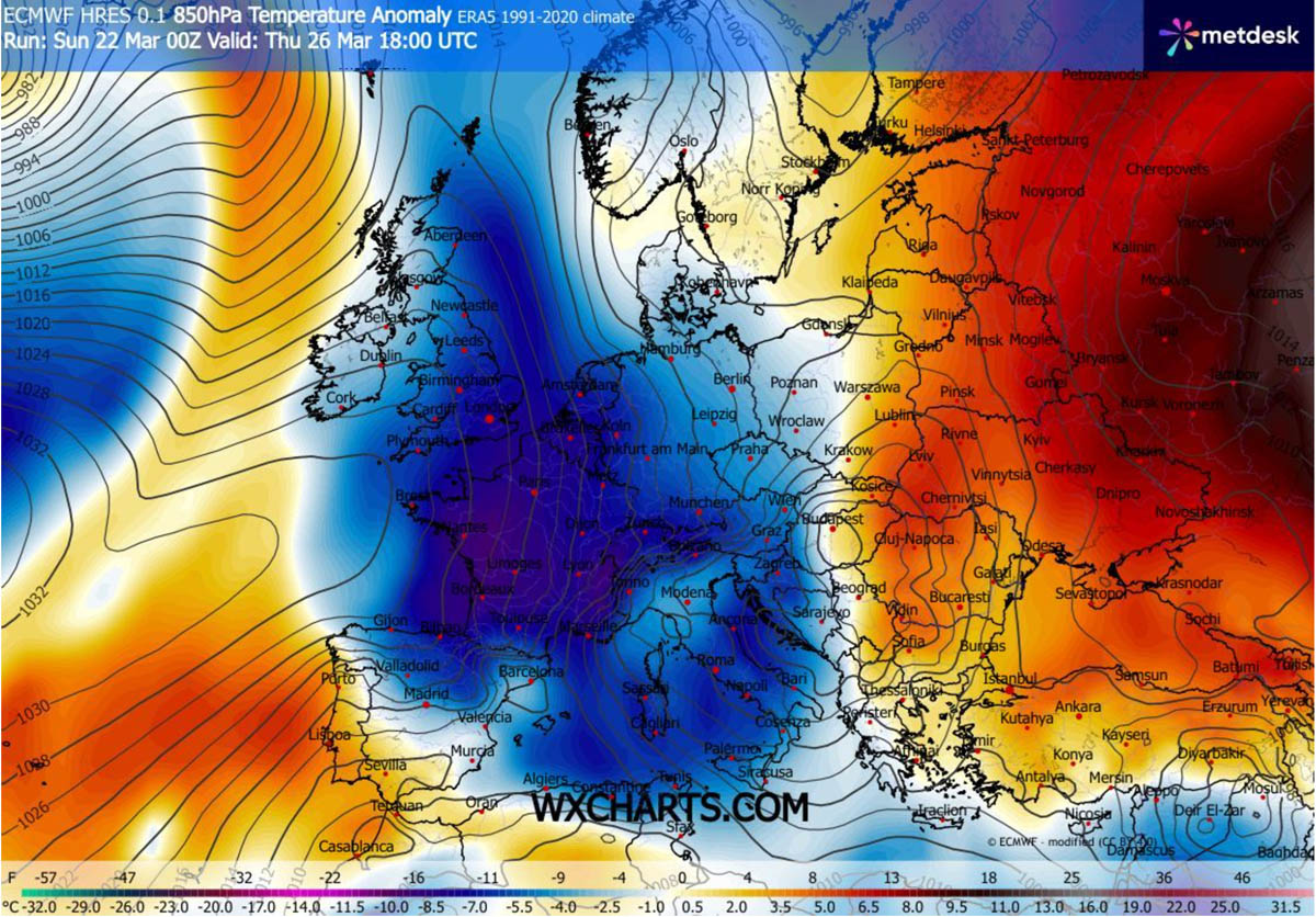
A significantly colder Arctic air mass follows behind a winter storm, with temperatures plunging 10-15 °C below normal for the end of March. Thus, sending the region back into winter in many areas.
A lot of fresh snow is forecast as the Polar front delivers significant cold far south, with traces of snowfall possible from the UK into Benelux to France, with some local, more measurable amounts.
Much more snow is forecast across Central Europe, particularly over the Alps and the western Balkan peninsula.
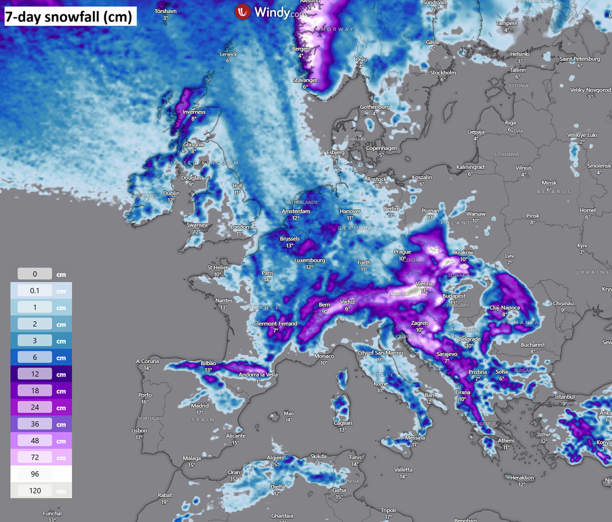
Thanks to a deep secondary low forming on Thursday, abundant snowfall is expected, with local accumulations of 20-40 cm and much higher in the mountains. Part of the northern Alps could see 75-100 cm of fresh snow by Sunday.
Fresh snow is also likely to accumulate across northern Spain, the Pyrenees, eastern France, and the higher terrain of central Italy, possibly also over the mountain tops of Corsica and Sardinia. A lot of snow is forecast for the Western Balkans, and travel disruptions are expected.
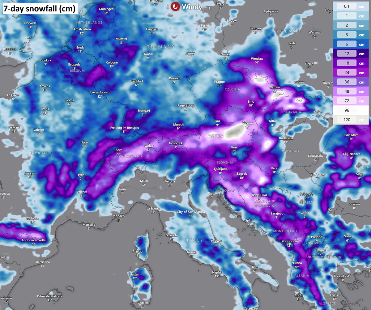
As the cold reaches North Africa, snow will be possible in Morocco and Algeria on Thursday and Friday as well.
Strong Arctic cold spreads deep south, and the temperature plunges below freezing behind the Polar front
Cold days will follow behind the frontal system and winter storm, as a large cold pool develops and persists for days. Therefore, increasing the potential for frosts in agriculture.
Western Europe
The coldest air mass will be over Western Europe on Wednesday and Thursday, with morning lows down to -2 °C over England, Northern England, Wales, and Ireland. Even colder will be over Scotland.
More cold will develop over France and the Benelux on Thursday, with temperatures plunging to -2 to -6 °C in many regions.
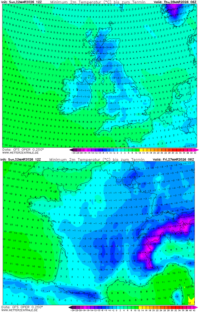
This cold will also persist on Friday and Saturday when it finally decays. These low mornings will likely be damaging for the vineyards and fruit orchards.
Central Europe
Very cold late March temperatures will also spread across Germany, the Alpine region, and Czechia by Thursday and Friday, with locally morning lows below -5 °C. And much more into the Alpine valleys.
Similar conditions are also likely over the northern Balkans, with a few degrees below freezing on both days.
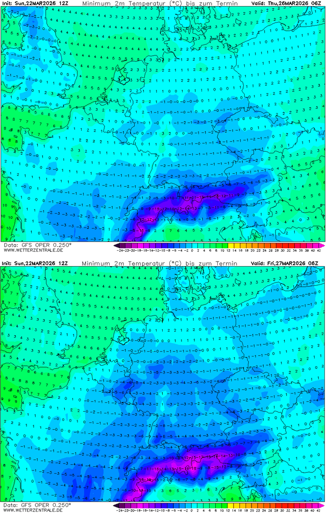
Conditions will remain similar into the weekend, with a large cold pool stalled over the Balkans at least until Sunday.
Mediterranean and the Balkans
A closer look at the Mediterranean region and the Balkan peninsula hints that unseasonably cold temperatures will spread far south into Southern Europe as well. Morning lows on Friday and Saturday will be from 0 to -4 °C in parts of Italy.
Below-freezing temperatures are also likely in parts of Corsica, Sardinia, and Sicily. Indeed, also over northern Algeria on both days.
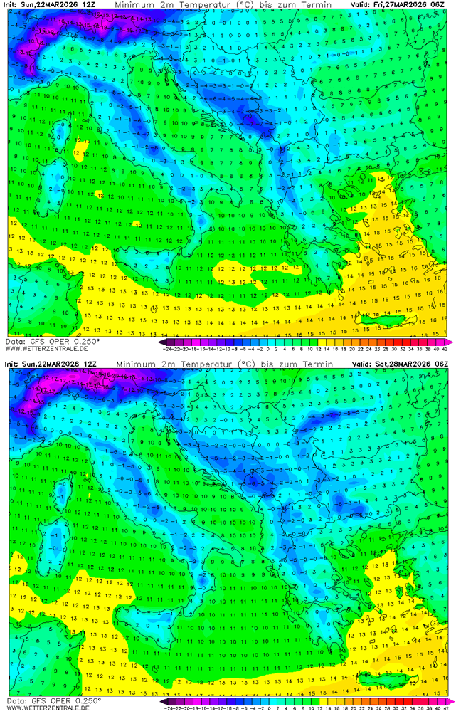
Over the Balkans, temperatures are forecast to plunge below freezing from Thursday to Sunday, with mornings ranging from -1 to -6 °C each day. Daytime high temperatures will also remain very low due to persisting cloudy and windy conditions.
The mid-term trends suggest that dynamic weather will remain active also into early April, with alternating cold and warm periods over Europe. We will continue to monitor and update the outlooks as the pattern evolves, so bookmark our page. Stay tuned for further updates.
Also, if you have seen this article in the Google App (Discover) feed, click the like button (♥) there to see more of our forecasts and our latest articles on weather and nature in general.
Windy, PivotalWeather, and Wxcharts provided images used in this article.