


The Atlantic Hurricane Season 2025 is forecast to take advantage of the continuous warm water temperatures. The main energy support for tropical activity, the Ocean Heat Content (OHC), is very high this year. These conditions typically lead to cyclones strengthening faster than usual. And becoming more intense.
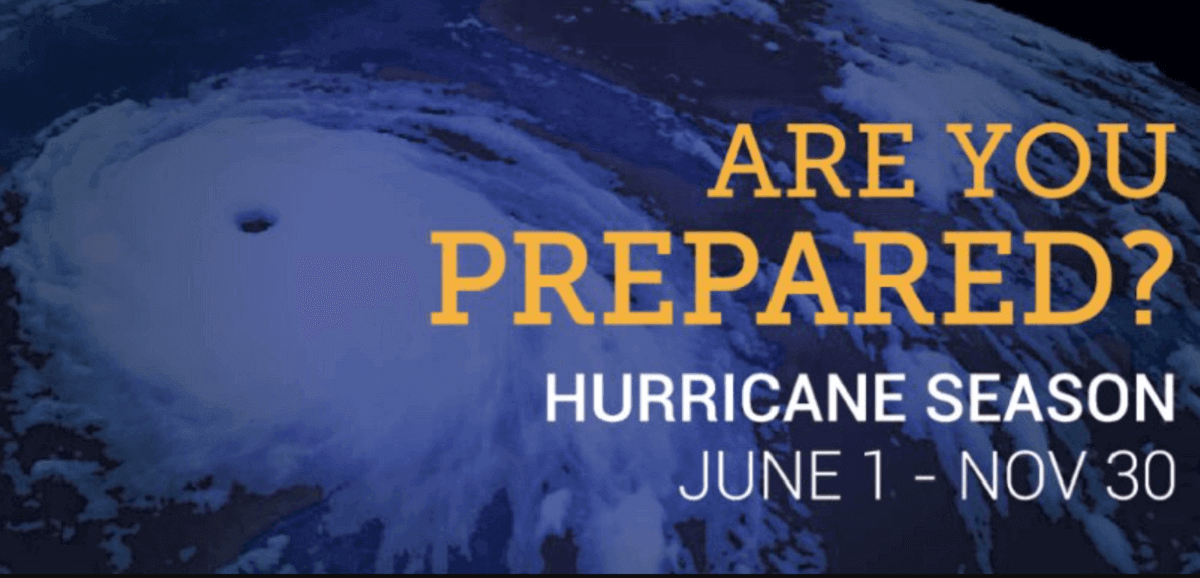
The official start of the Atlantic hurricane season is June 1st, and it runs through November 30th.
NOAA predicts a 60 percent chance of an above-normal 2025 Atlantic hurricane season. The agency is forecasting 13 to 19 named tropical storms this year, with 6 to 10 of those becoming hurricanes.
NOAA also predicts 3 to 5 hurricanes could reach major strength (Category 3 or greater).

As global weather is a very complex system of chaos theory, weather dynamics and patterns are also very different worldwide. Tropical dynamics are one of the more complicated things involving many factors—the perfect combination of these leads to dangerous tropical weather threats for land and property.
During an average tropical year, the Atlantic hurricane season produces up to 14 named tropical storms. On average, seven typically become hurricanes, with around 3 reaching major strength.
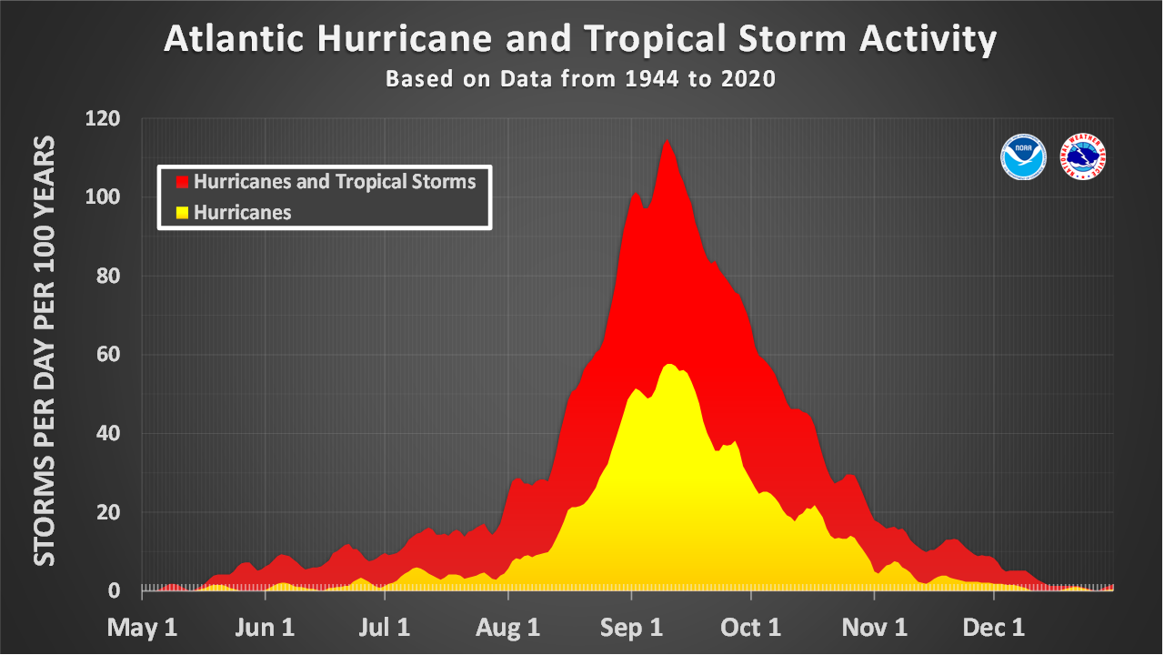
A typical Atlantic hurricane season has two peaks. The first period of increased activity occurs from early through mid-September, while the second boost typically happens through mid-October. Statistically, the general increase in activity across the tropical Atlantic typically begins in the trough early/mid-August.
ATLANTIC HURRICANE SEASON 2025 FORECAST
The 2025 Atlantic hurricane season officially starts on June 1st. After mid-August, activity typically increases toward its peak in September and October.
Based on the continuing warmer-than-normal sea waters of the North Atlantic and a related Ocean Heat Content (OHC), the energy support could increase activity, mainly in terms of the more rapid strengthening of tropical cyclones and their peak intensity. Research studies have found that the warmer the waters are, the higher the potential for more intense hurricanes.
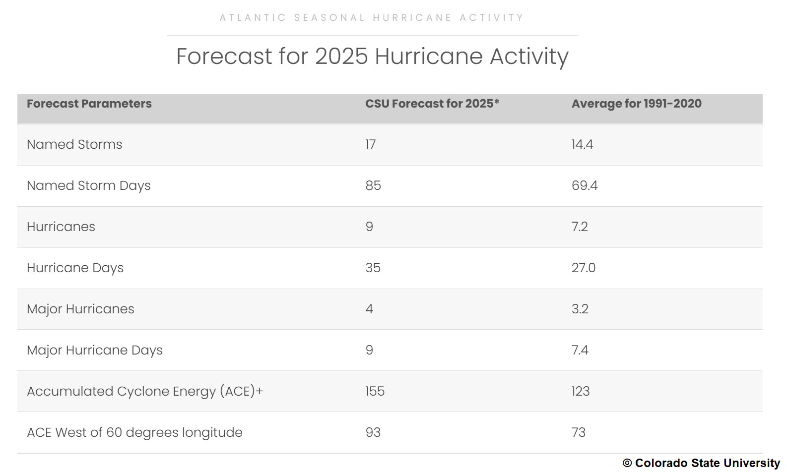
The seasonal forecasts from Colorado State University (CSU), led by Dr. Phil Klotzbach, hint at 17 named tropical systems, with nine hurricanes and four major storms forecast for hurricane season 2025. That’s well above the 30-year average.
Based on the long-term average, a hurricane season typically brings 14 named storms and seven hurricanes, three of which reach a major intensity (Category 3 or greater).
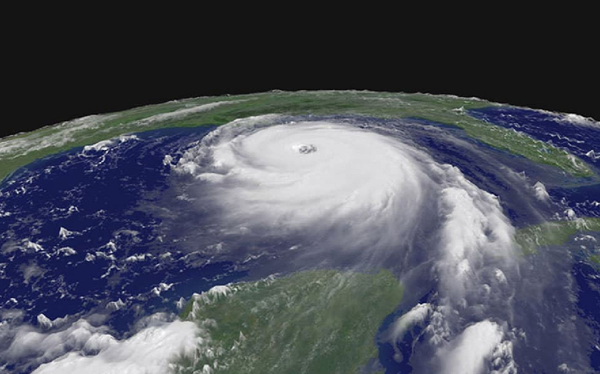
Judging by these pre-season outlooks from NOAA and CSU, the Atlantic hurricane season 2025 is likely to be similarly strong as the one we had last year, 2024. To keep things on track, the 2024 hurricane season produced 18 total systems, all named storms. Eleven strengthened into hurricanes, and five reached major strength (Category 3 or greater).
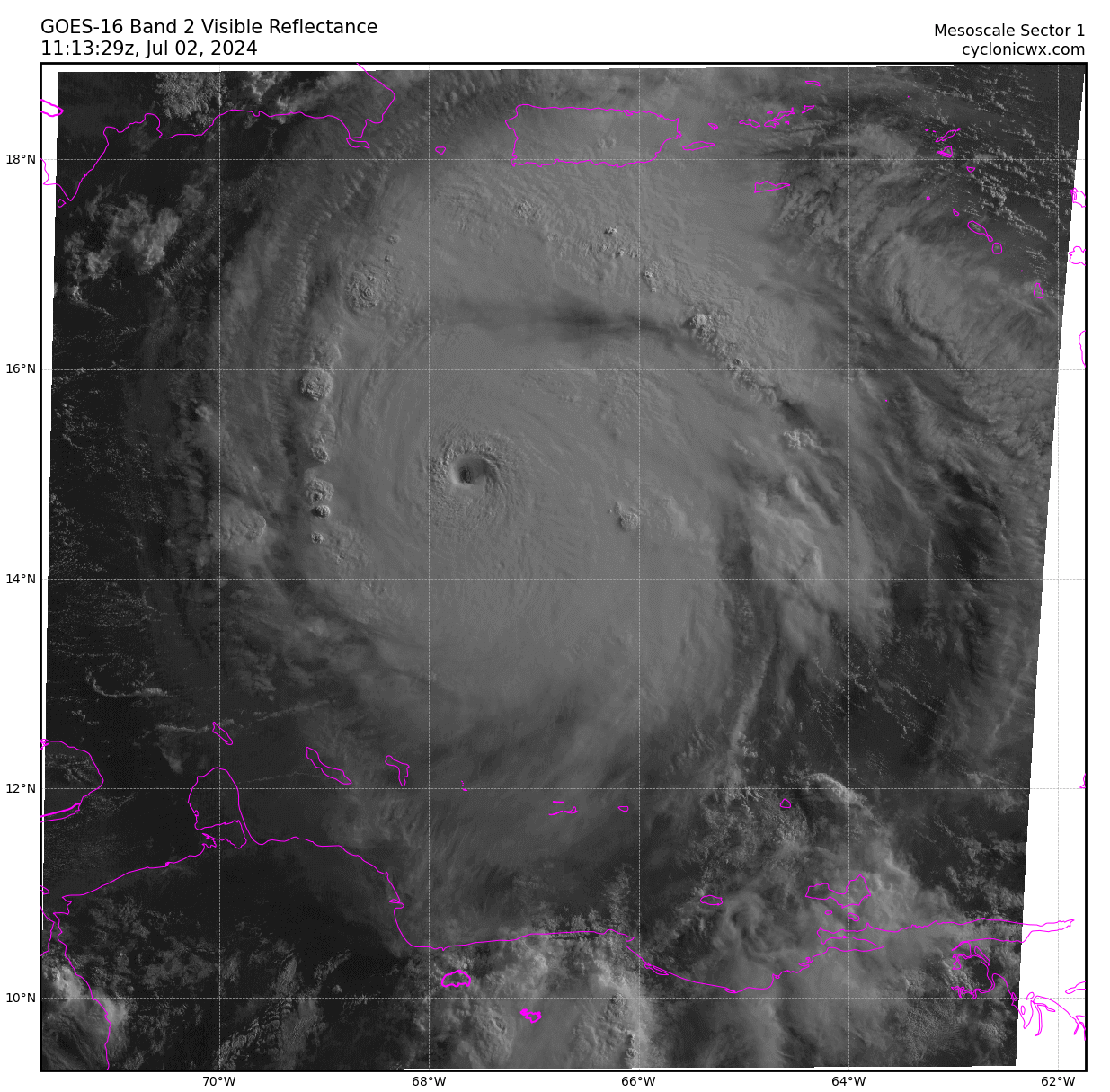
Those major hurricanes were Beryl and Milton (both Category 5), Helene and Kirk (Category 4), and Rafael (Category 3).
Below is a NOAA visible satellite view of Category 5 Hurricane Beryl on July 2nd, 2024, when it was grazing across the Caribbean Sea.
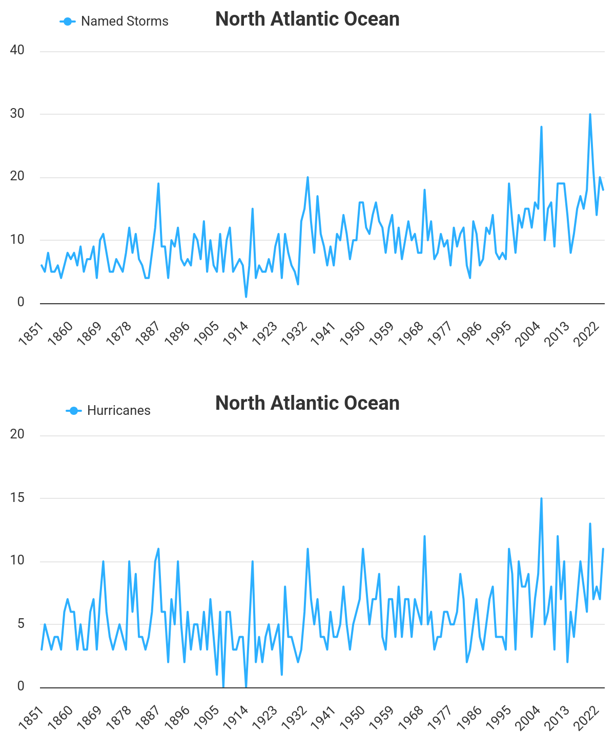
During the Atlantic hurricane season, we monitor tropical systems in the Atlantic basin, which covers the tropical area, including the entire Atlantic Ocean, the Gulf of America, and the Caribbean region.
The long-term average of tropical systems in the Atlantic Basin (taken over the last 70 years, between 1951 and 2020) holds 11 named storms in one full hurricane season. However, the short-term average (taken in the previous 15 years, between 1995 and 2020) is higher, with around 14 named storms.
We can notice a gradual increase in storms and hurricanes developing.
While a La Nina global weather pattern influenced the 2020-2022 seasons, the 2023 hurricane season had an El Nino effect. Last year’s hurricane season had a neutral ENSO phase, and similar conditions are predicted for late 2025, when activity peaks.
Note: The El Nino leads to less tropical activity due to stronger wind shear in the Atlantic Basin, while the La Nina generally brings more activity due to reduced wind shear. With the 2025 Atlantic hurricane season coming after a weak La Nina over the last winter, it will likely affect low shear for the upcoming months.
Therefore, this year’s well-above-average Atlantic seawater temperatures and the high ocean heat content mean the upcoming hurricane season is again expected to be busy. These warmer-than-normal sea temperatures are observed especially across the Caribbean and the Gulf of America.
The video animation above represents the global and tropical regions’ sea temperature anomaly over the last 90 days; temperatures are well above normal. We can see how near-normal the Pacific waters are developing, meaning there is no El Nino or La Nina, so the Neutral phase is underway.
At the same time, the Atlantic, the Caribbean, and the Gulf are warmer than usual, including across the region known as MDR (the Main Development Region – between Africa and the Caribbean Sea).
This indicates that upcoming tropical cyclone formation will be fueled by the very warm and hottest-than-ever ocean waters when hurricane season activity ramps up.
A tropical storm or hurricane organizes and gains its strength when specific weather conditions are met. Typically, hurricanes need a low-shear environment with very warm sea waters, which results in plenty of very moist air mass above the sea.
Measuring tropical cyclone energy – ACE Index
Furthermore, the Accumulated Cyclone Energy (ACE index) is used to measure and predict the strength of the hurricane season. This metric expresses the energy a tropical cyclone uses during its lifetime. The calculation multiplies a tropical cyclone’s maximum sustained winds every six hours to generate the values.
William Gray and his associates at Colorado State University (CSU) created the calculation known as the Hurricane Destruction Potential Index. It multiplies each hurricane’s maximum sustained winds above 65 knots (120 km/h = 75 mph) every six hours.
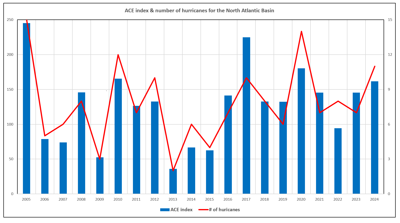
Above: ACE index and the number of hurricanes in the North Atlantic Basin over the last 20 years
The NOAA subsequently tweaked the ACE index in 2000 to include all tropical cyclones with winds above 35 knots (65 km/h = 40 mph) and renamed it Accumulated Cyclone Energy (ACE).
NOAA uses the ACE index, combined with the number of named storms, hurricanes, and major hurricanes, to categorize North Atlantic hurricane seasons as above, near, or below normal. Within the Atlantic Ocean, NOAA classifies hurricane seasons into four categories.
- Extremely active – ACE above 152.5
- Above-average – ACE above 111
- Near-average – ACE between 66 and 111
- Below-normal – ACE below 66
The CSU forecast for 2025 predicts an ACE index of 93, which is nearly 30% above the long-term average.
Further reading about ACE: Understanding the ACE Index: Measuring tropical cyclone energy.
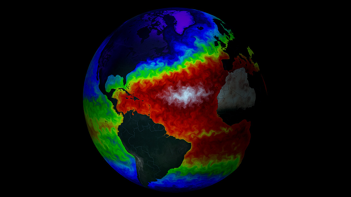
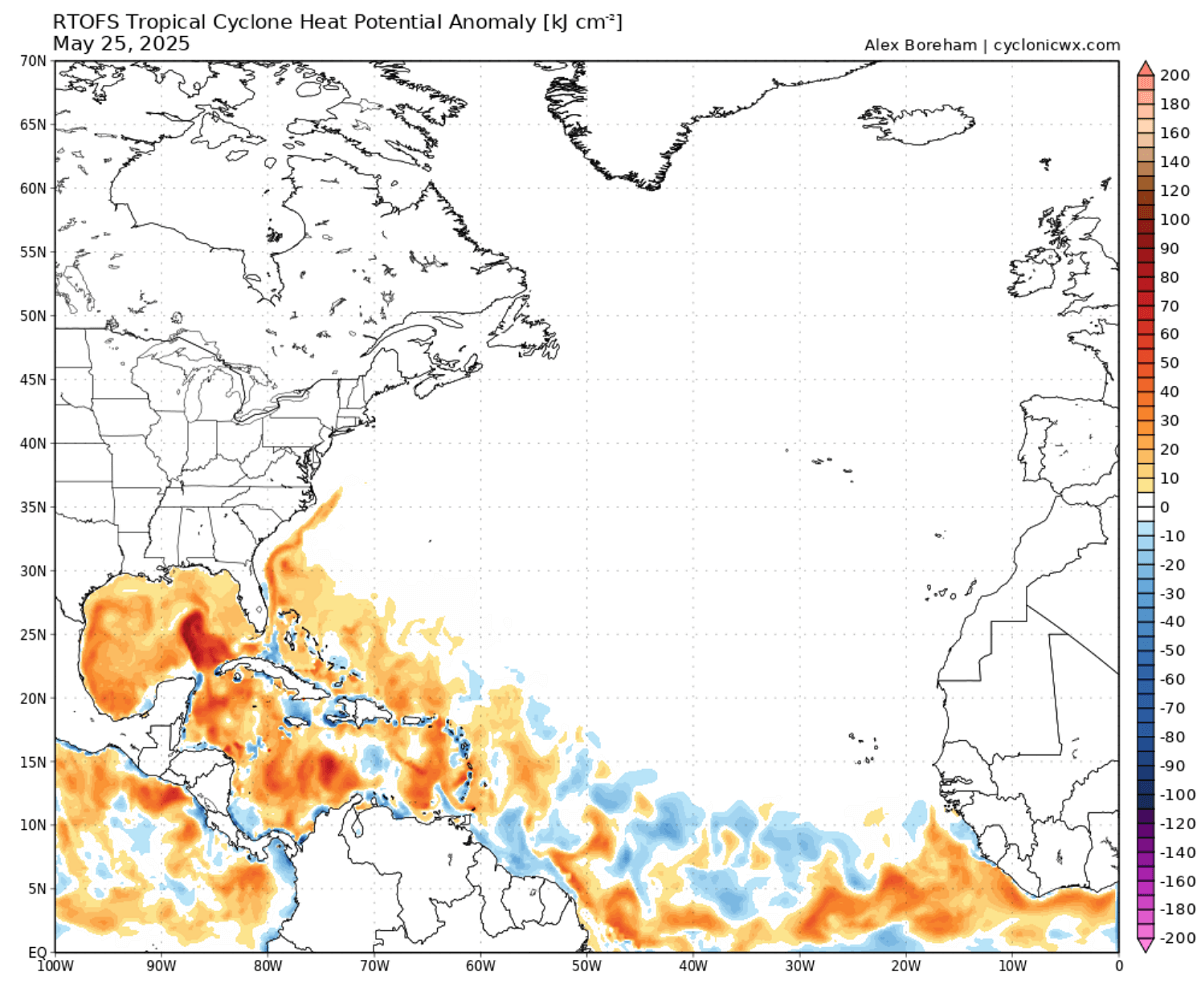
North Atlantic remains very warm, with high Ocean Heat Content (OHC) forecast in 2025
Water temperatures across the North Atlantic, including the Main Development Region, have remained above normal since the 2024 season. This means that one of the main conditions fueling tropical cyclones is particularly anomalous—the heat content.
Below is the Ocean Heat Content map at the end of May 2025. Conditions are already above normal across the western Atlantic basin, from the Caribbean Sea to the Gulf of America.
For a tropical storm and a hurricane to form, two meteorological features must be present:
- A weather disturbance, such as a cluster or thunderstorm, that pulls in warm surface air (dewpoints) from all directions
- The water at the ocean’s surface has to be at least 79° Fahrenheit (26° Celsius)
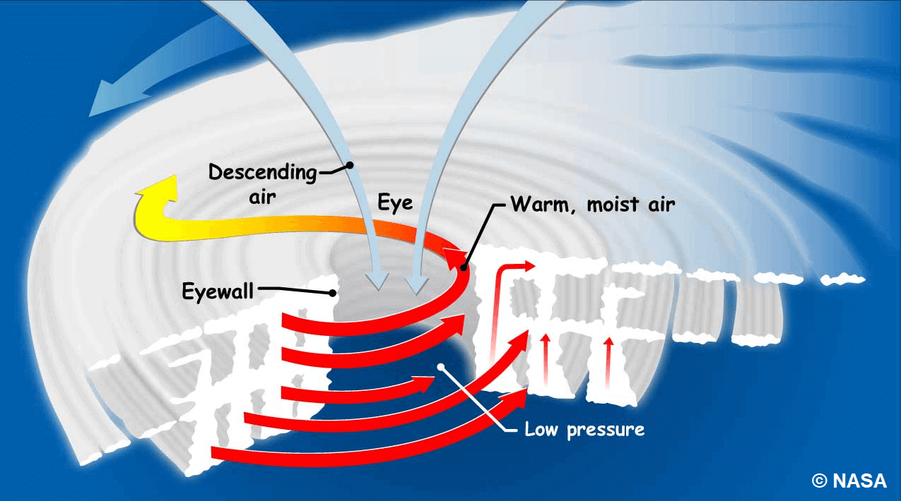
Because we interact with warm air and seawater that spawn these storms, tropical cyclones form over the oceans between about 5 and 20 degrees of latitude. At these latitudes, seawater is warm enough to give the storms strength, and the rotation of the Earth then makes them spin.
Hurricanes generally start with evaporating warm seawater, which pumps water into the lower atmosphere. This significantly humid air mass is dragged aloft when converging winds collide and turn upwards.
As air rises into higher altitudes, water vapor condenses into clouds and rain, releasing heat that warms the surrounding air, causing it to rise. The air far above the sea moves upward, and even warmer, moist air spirals in from along the surface to replace it.
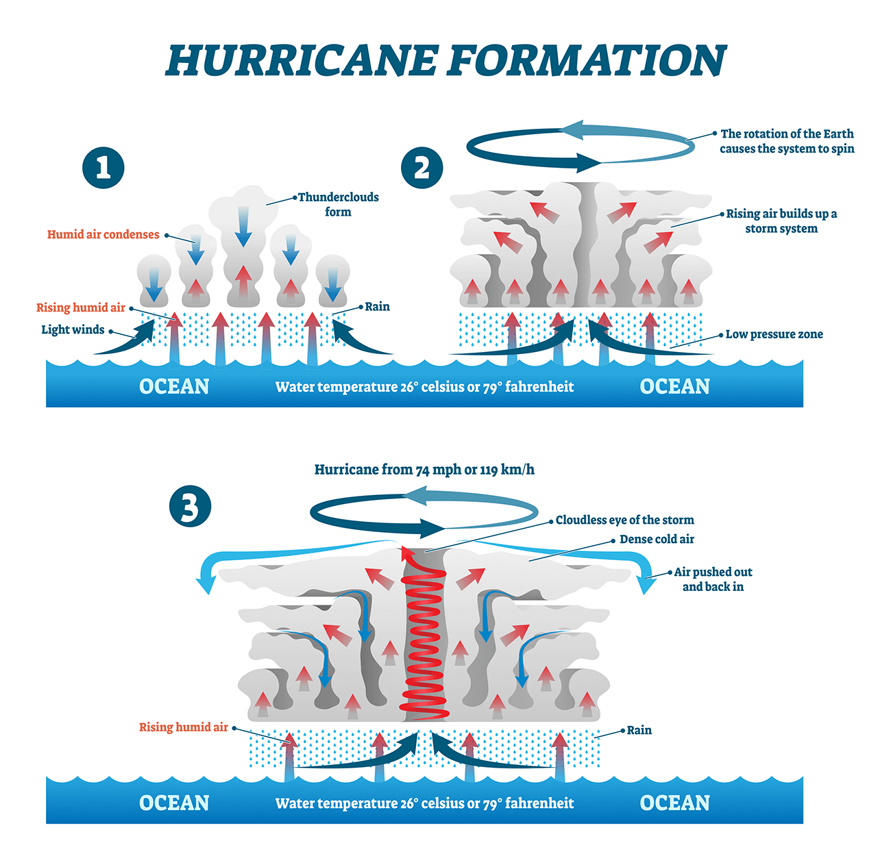
Therefore, as long as the base of this weather system remains over warm water and high-altitude winds do not shear apart its top, the tropical cyclone will strengthen and grow. More and more heat and water will be pumped into the air.
The surface central pressure at its core will drop further, sucking in the wind at ever-increasing speeds. Over several hours to days, the tropical storm (cyclone) will intensify, finally reaching hurricane strength.
A tropical system in the Atlantic officially gets a Hurricane status when the winds that swirl around it reach sustained speeds of 74 miles per hour (64 knots or 119 km/h) or more.
Warmer oceans provide more potential energy for tropical systems, leading to stronger storms or even more rapid intensification when they grow. Recent studies have shown a link between ocean surface temperatures and tropical storm intensity—warmer waters lead to more intense storms.
So, as we learned, the two main ingredients tropical systems need for their formation and strengthening are (1) a weather disturbance and (2) warm ocean waters. The latter has been in the record values for the whole North Atlantic.
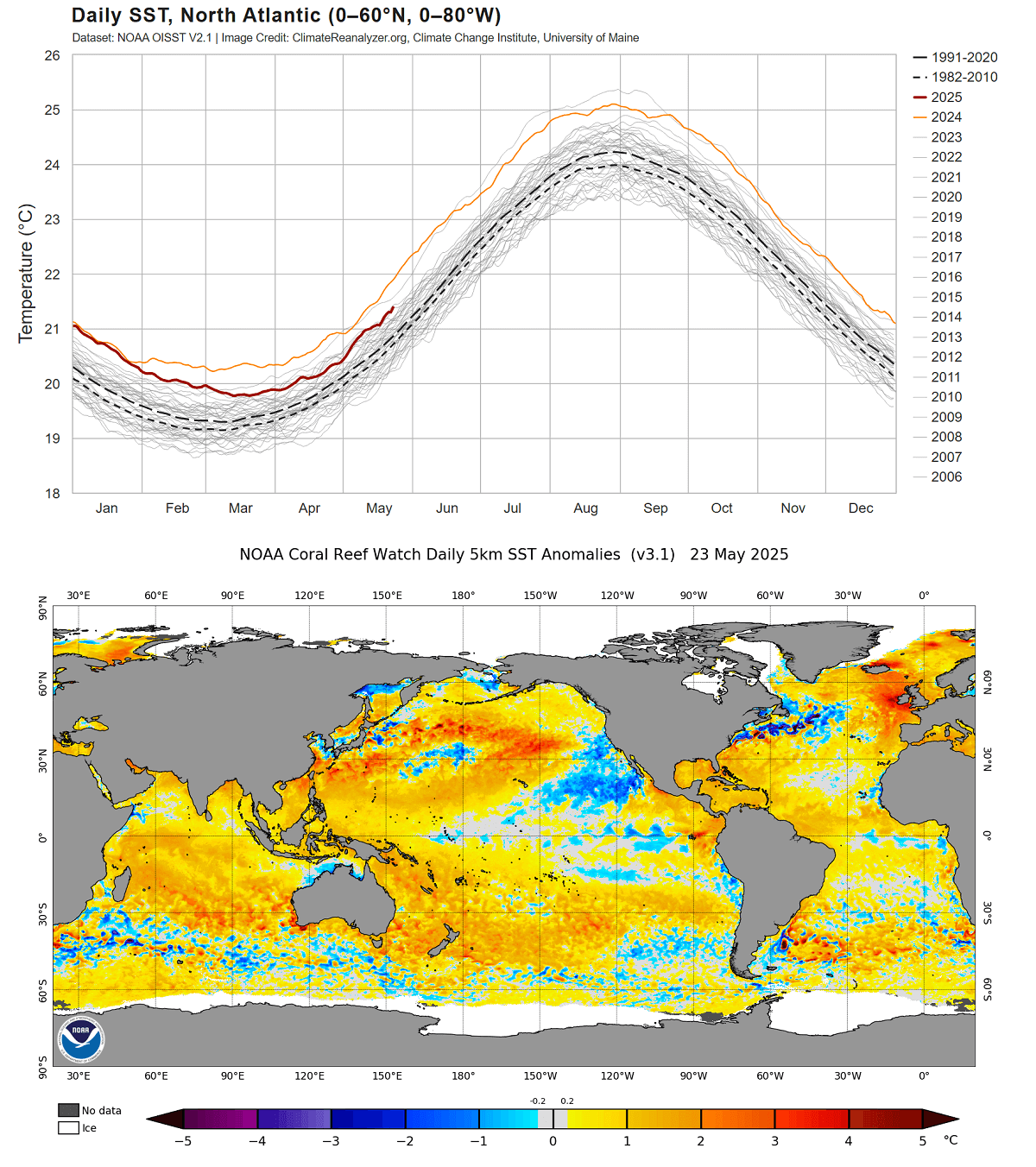
The above chart represents the Atlantic Ocean’s average temperature over the years, with the 2025 curve remaining above normal. Oceanic waters have been continuously anomalous over the last few years, especially significantly above the long-term average in 2024.
In other words, it is hard to find near or below-normal temperatures right now; the Atlantic Ocean is very warm. Usually, when the hurricane activity comes closer to its statistical and seasonal peak, generally in September, the North Atlantic waters warm more as well.
NOAA has designated 21 tropical cyclone names for the Atlantic Hurricane Season 2025
The international committee of the World Meteorological Organization (WMO) has designated 21 storm names for the Atlantic hurricane season 2025. The 2025 list with all the storm names, from Andrea to Wendy, can be seen below.

Above: The Atlantic hurricane season 2025 will use the following names: Andrea, Barry, Chantal, Dexter, Erin, Fernand, Gabrielle, Humberto, Imelda, Jerry, Karen, Lorenzo, Melissa, Nestor, Olga, Pablo, Rebekah, Sebastien, Tanya, Van, and Wendy.
To obtain the most valuable information from a storm naming system, NOAA meteorologists alphabetically arranged a list of names.
Therefore, this year, a storm with a name that begins with the letter ‘A,’ Tropical Storm Andrea, will be the season’s first storm. The last letter is ‘W.’ Therefore, Wendy, it would be for the hurricane season of 2025.
Besides simple storm names, the general media also finds it easier to report on tropical systems forming, so the warning messages with storm names are straightforward information for anyone involved in their path.
Ultimately, these simple messages increase public awareness, particularly regarding dangerous weather events.
Furthermore, the advantages of the storm names are pretty significant in exchanging detailed information about the ongoing systems between various users, including coastal bases and ships traveling at sea, and indeed also between the various meteorological offices (e.g., Storm Prediction Center, which focuses on convective outlooks across the U.S. and the National Hurricane Center).
Note: Their names are retired if hurricanes develop historic proportions or become deadly or costly to life and property. If any retired names for the recent hurricane season occur, the World Meteorological Organization (WMO) will always announce them in the spring months. The retired name is then replaced by another one.
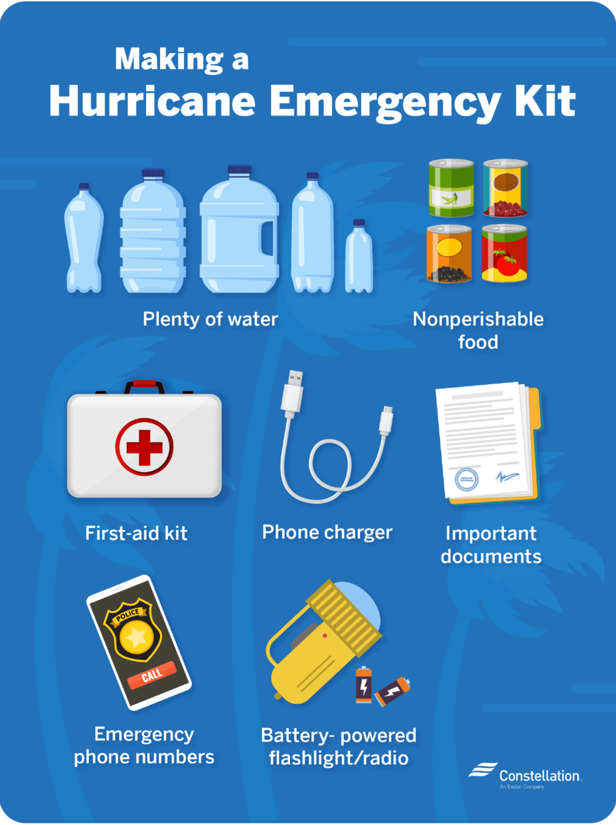
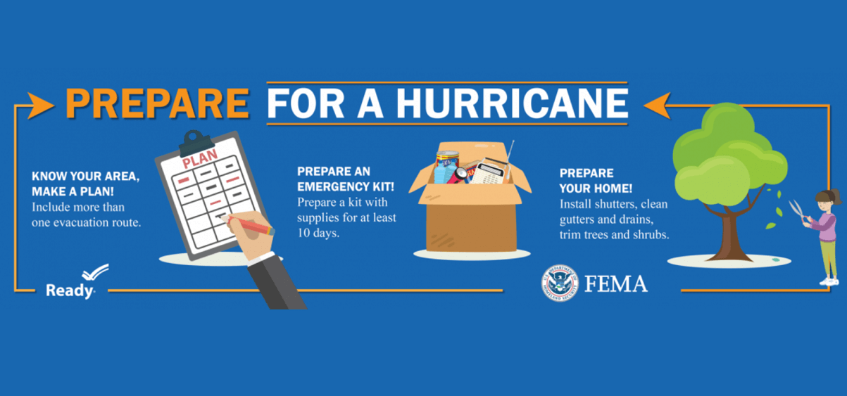
Safety Preparedness during a Hurricane Season
Have a plan
The official hurricane season in the North Atlantic and the Caribbean starts on June 1st and ends on November 30th. This is when you and your family must be prepared by planning.
- Write emergency phone numbers and keep them on the refrigerator or near every phone in your house. It would help if you also programmed them into your cell phone.
- Prepare an emergency supply kit.
- Locate the nearest shelter in your area and different routes from your home in an emergency. If shelter locations in your area have yet to be identified, learn how to find them before the event of a storm.
- Pet owners: Take care of your pets at pre-identified shelters, a pet-friendly hotel, or an out-of-town friend or relative where you can take your pets in case of an evacuation. Local animal shelters can offer advice on what to do with your pets if you are asked to evacuate your home during a hurricane.
Learn the difference between a hurricane “Watch” and “Warning”
When you listen to the National Weather Service alerts on TV or radio or check for them online, there are two kinds of alerts:
- A hurricane watch means hurricane conditions (sustained winds of 74 miles per hour [mph] or higher) are possible in a stated area. The National Hurricane Center (NHC) will announce hurricane watches 48 hours before it expects tropical storm-force winds (sustained winds of 39 to 73 mph) to start.
- A hurricane warning is a more severe threat. This means that hurricane-force winds are expected in a stated area. NHC issued these warnings 36 hours before tropical-storm-force winds were expected in the area to give people enough time to prepare for the storm.
Check out the National Weather Service’s Hurricane Center for more information about hurricane watches and warnings. If you hear a hurricane watch or warning in your area, you can take steps to get ready.
Get your car ready to leave home if needed
Make sure your car is ready before the tropical storm or hurricane hits.
- Fill the gas in your car’s tank.
- Move cars and trucks into your garage or under cover.
- Always keep an emergency kit in your car.
If you don’t own a car, consider making plans with friends and family or calling the authorities to get a ride if you need to evacuate.
Get your family and pets ready
- Go over your emergency plan with your family; understand everything.
- Keep checking for weather updates about the storm. You can watch TV, listen to the radio, or check the NHC website online.
- Call the hospital, public health department, or the police about special needs. If you or a loved one is older or disabled and won’t be able to leave quickly, get their advice on what to do.
- Put pets and farm animals in a safe place.
Get your home ready
- Clear your yard to ensure nothing can blow around during the storm and damage your home. Move bikes, lawn furniture, grills, propane tanks, and building materials inside or under the shelter.
- Cover up house windows and doors. Use storm shutters or nail pieces of plywood to the outside window frames to protect your windows. This can help keep you safe from flying debris and pieces of shattered glass.
- Be ready to turn off your power if you see flooding, downed power lines, or have to leave your home. Switch your power off completely.
- If you lose your water supply during the storm, clean containers with drinking water. You can also fill your sinks and bathtubs with water for washing.
- Double-check your carbon monoxide (CO) detector’s battery to prevent CO poisoning.
Be ready to evacuate or stay at home
During a hurricane warning, always listen to authorities regarding whether you should evacuate or stay home.
If a hurricane is coming, you may hear an order from authorities to evacuate (leave your home). Never ignore an order to evacuate. Sturdy, well-built houses may not hold up against a hurricane’s power. Staying home to protect your property is not worth risking your family’s health and safety.
There are occasions when you may hear an order to stay at home. If driving conditions are too dangerous, staying home might be safer than leaving. Respect the authorities’ decisions.
If you need to evacuate:
- Grab your emergency supply kit and only take what you need (cell phone, chargers, medicines, identification like a passport or license, and cash).
- Unplug your appliances. If you have enough time, turn off the gas, electricity, and water.
- Follow the roads emergency workers recommend, even if dense traffic is expected. Other routes might be blocked or already flooded. Never drive through flooded areas, as cars and other vehicles can be swept away or may stall in just 6 inches of moving water.
- Contact your local emergency management office and ask if they offer accommodations for owners and pets.
If you need to stay home:
- Keep your emergency supply kit somewhere you can easily access it anytime.
- Follow weather updates online from NHC, and listen to the radio or TV for updates on the hurricane.
- Stay inside. Even if it looks calm, don’t go outside. Wait until you hear an official message that the hurricane is over. Sometimes, the weather gets calm in the middle of a storm, but then quickly worsens again.
- Stay away from windows. You could get hurt by flying debris, such as pieces of broken glass or other objects picked up by winds around the neighborhood during the storm. Stay in a room without windows or go inside a closet.
- Be ready to leave home. If emergency authorities order you to leave or your home is severely damaged, you may need to go to a shelter or a neighbor’s house.
Our expert forecaster team will actively follow the tropical region activity worldwide, including Atlantic Basin systems and tropical cyclones likely to affect the United States, the Caribbean, and Europe again in the following months.
Stay tuned for further follow-up posts, in-depth forecast discussions, and nowcasting during the coming weeks and the upcoming Atlantic hurricane season 2025 peak months. We will prepare you.
Remember to bookmark our page to have all the new info ready anytime. Or click ‘show more’ if you read this article from the Google Discover feed.
Copernicus, Climate Reanalyzer, NOAA, NHC, Colorado State University, and WHO provided images used in this article.
See also:


